PAGE CONTENTS
Weather Storms
API Name: weather-storms
Introduction
Storm forecast, location and history is retrieved using the storms API.
Overview
Storm feeds come directly from the South African Weather Service (SAWS) and are arranged into three storm intensities and a convective hail feed as well as a feed derived from satellite imagery.
The storm intensities are 30 dBZ, 48 dBZ and 60 dBZ, and only storms above these intensities are included in the feed. dBZ is decibel relative to Z and is a logarithmic dimensionless technical unit used in radar.
Only severe storms will be in the storm group of 60dBZ feed, and there will obviously be fewer storms than in the 30 dBZ feed, which would also include milder storms. One or more of the feeds can be queried at once for each of the calls below.
View more information on storm intensities.
Storm Forecast
Information on the storms forecast for the next 60 minutes at a given location is returned. A buffer distance can be specified that will be added to the location. This location is provided as a set of coordinates. A Boolean value indicating whether there is any overlap with a predicted storm is provided, and if so, what the maximum storm intensity will be.

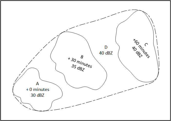
The forecast (D below) is a combination of the SAWS current storm (A) and the predictions for the next 30 minutes (B) and 60 minutes (C). The maximum storm intensity of D is the maximum of A, B and C.

Optionally, a higher dBZ threshold than the default of 30 dBZ can be specified, in which case only more intense storms will be considered.
Storm Location History
Storm history at a given location and time is retrieved. A buffer distance can be specified and will be added to the location. A Boolean value is returned indicating whether there is any overlap with a storm, and if so, a summary of what the closest distance and the maximum storm intensity was.
In the image below, A and B are two different storms, at times t0, t1, t2 and t3. Only instances overlapping the circular buffer around different query locations (Loc 1, Loc 2, Loc 3, Loc 4) will return a distance (a – g) and the storm intensities. Note that g = 0 because Loc 3 is within B at time t3. No results are returned for Loc 4 as there is no overlap with either storm.

Optionally, a higher dBZ threshold than the default of 30 dBZ can be specified, in which case only more intense storms will be considered. For satellite feeds, a dBZ value of “1” must be specified in the API request.
Storm Historical Details
The full thunderstorm history (excluding the forecast) for a given period is retrieved. It returns the following information on the storm:
- Geometry
- Ellipse representation
- Centroid coordinates
- Speed and direction
- Age
- Cell top
- Intensity
A location and buffer distance can be provided that will be further added to the location for the historical data to be filtered only for overlapping storms.
The ellipse representation of the storm is returned by default (see the diagram below).

Optionally, a higher dBZ threshold than the default of 30 dBZ can be specified, in which case only more intense storms will be considered.
Active Storms Feed
This makes the entire thunderstorms data feed from SAWS available. It returns the current and forecast storms for now, 30 minutes and 60 minutes. Data includes:
- Geometry
- Ellipse representation
- Centroid coordinates
- Speed and direction
- Age
- Cell top
- Intensity
Only the latest data file from SAWS is returned. If there are no storms in the data, then none are returned.
Optionally, a location and a buffer (that will be added to this location) can be provided, and the data feed will be filtered to only overlapping storms.
The ellipse representation of the storm is returned by default (see the diagram below)

Optionally, a higher dBZ threshold than the default of 30 dBZ can be specified, in which case only more intense storms will be considered.
Authentication
This API makes use of OAuth2 authentication. To integrate, sign up for a free trial account by contacting [email protected]
For detailed integration instructions using OAuth2, please click on the following link: https://developers.afrigis.co.za/oauth2-authentication/
To view technical documentation describing the details of Weather Storms, click on the button below.


